Planes and more planes

The easy hop to Madrid reminds me of my day job too much to be excited, but then boarding the LATAM flight to Santiago de Chile made me start to feel I am actually on a different journey this time. My change of approach was also confirmed, when I tried to board the wrong flight to Santiago. I haven’t done that for years and had a quick panic and prayer that the correct flight gate was not too far to “jog”. I’m sure I should start Strava logging all these flight transfers and my fitness might go up on file as well as in my head. (What does Sara say – If its not on Strava it didn’t happen?)

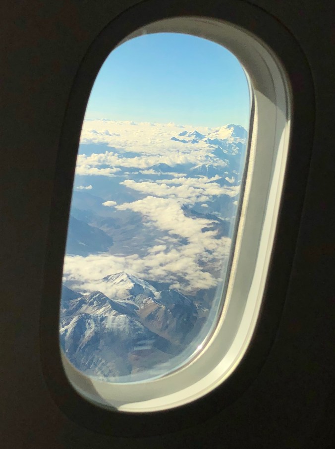
So now I’m sitting in relative comfort in Santiago airport after a flight which took almost 14hrs. The usual Immigration, Baggage customs and re check in done. The view crossing the Andes was impressive. As were the electronic blinds which confirmed I was on a new Boeing Dreamliner. Impressive plane!

IMG_7695

I have a few hours to kill and manage to finish the budget files for next year which was one of the must do jobs left on my list. You’re never too far away from the day job, but tonight I will be in Punta Arenas and have different priorities for a couple of weeks.

I’m looking forward to the next leg of this trip, where I will be flying with the mountains on the left of the plane for the whole trip.  I should have planned ahead and reserved a window seat. An error I have corrected for the return leg. I might be getting a bit friendly to whoever has that window seat.


Heathrow to Punta Arenas

After an easy trip down the M4 I’m at Heathrow well ahead of schedule. I’v had too many flights to want to rush to airports these days. Working at the desk or the airport makes no difference, so why stress?

IMG_7689.jpg

Thanks to Johanna from Intel for the last minute hints and guidance for using the Sirius Pro in the extreme conditions. Your offer of direct support connection is greatly appreciated. You might even be getting that sat link call from the other side of the world.

It’s Time

Lots of preparations have gone in to this day and managing this on the side of a very busy job with lots of international travel hasn’t been easy, but I’m looking forward to the next chapter. Today I’m heading to Heathrow for the flight to Chile.

The adventure begins

What about me?

Now the kit is on its way it was time to start thinking about me and what will I need to work and live while in Antartica.

ALE will be taking care of me to get there and while I’m on the ice so I really only need to think about personal kit.

How many layers…. which gloves ( which ended up as all of them) which coat? Etc… ALE provided a good list of items which I would need and this was a great excuse for a shopping trip ( or browse).

Kit away

After lots of training and organising the time has come to ship the survey kit to Punta Arenas in Chile which will be the departure point for Antartica.

Thanks to Antarctic Logistics and Expeditions for organising the shipment of 125kg of kit.

I packed up the car and dropped of the boxes to the freight company next to Heathrow airport while on route to a business meeting in London. I had decided to also take a drone to film the project in Antartica so I experimented with a few flights and made my first movie.

I think I need to get better at this.

Taking Flight…

One of the methods I want to test when in Antartica will be to survey the surface using photogrammetry captured from a UAV/Drone.

Topcon have been selling the Sirius UAV for some time now and in my job I need to know the products we sell and where they can be best utilised. Measuring snow and ice will be challenging as photogrammetry relies on images having sufficient “texture” and uniquely identifiable pixels. There should be texture with ice but this is the unknown for the location we will be visiting.

Knowing the products and their applications is not enough for this job as I will need to know how to use them too. Thanks to Rene Dikken and Mat Kellett for sorting out the loan of the Topcon Sirius Pro and training me how to use it.

I am looking forward to this task in Antartica even though it is one of the jobs where we are not so sure of the outcome yet. More to follow on this one.

Boxes and more boxes

The time is getting closer to have all the survey equipment shipped to Antartica. I wanted to check and configure all the equipment to make sure it was set up correctly before it was shipped so I received a LOT of boxes from Topcon’s warehouse in Holland. One of the more recent restrictions around LiPo batteries was the reason for so many boxes. Now its only possible to ship 2 batteries in a box if packages are sent by air and not restricting the choice of using cargo only  aeroplanes. This is a safety requirement aimed at preventing fires. There were instances of batteries catching fire in the past, so its a good policy but it is frustrating when you have well developed, professionally manufactured batteries having to follow the same restrictions caused by issues with “cheap” copies.

Trigonometry

Many times I used to think at school – when will I use trigonometry in real life? Well in surveying it is “most of the time when measuring”.

When the airstrip is located and surveyed it will be necessary to map the surrounding mountains to have a plan for pilots to understand the surrounding dangers if the visibility is poor or they need to take emergency actions.

It would be great to climb all the mountains to survey the tops, but this is not practical or very time efficient. Instead I will be using a Total Station to measure the horizontal and vertical angles to the surrounding mountains from two points I will have surveyed on the glacier. With the coordinates of the two know points and the angles from these points to the mountains I will be able to calculate the coordinates and heights of the mountains. This is simple “Trig”, which gets a bit more complicated to get better accuracy when you take into account the curvature of the earth and the refraction of the measurements caused by the atmosphere.

I think i will need to get my old text books out for that one….350px-Circle-trig6.svg

(Image from Wikipedia)

Testing Testing 1.2.3

It was time to test some of the equipment i would be using and to set up methods to survey if the normal RTK methods failed in the low temperature.

To survey the ice field it will be necessary to cover a lot of ground quickly. We plan to  use skidoos. Obviously I can’t test skidoos on a November afternoon in Wales, so I improvised by mounting the Topcon GNSS on my cross bike.

With the FC-5000 mounted on the bars to keep me on a defined grid pattern I set off well to record some local fields in Real Time Kinematic and also Post Processed Kinematic. This Grid feature worked surprising well I was happy that the preferred method of surveying should work well in Antartica.

IMG_7065

Time to get serious

After understanding what would be required, I started getting the first of many lists together. What will I need to carry out a survey like this? Will I need to make any special modifications for the climate? Will it work? What about the back up plans and equipment to make sure I can get the job done if my first choice doesn’t work? All this before I started thinking what I will need to survive and work in a place like Antartica!

I decided the best surveying equipment to take would be GNSS as this is accurate and quick to get the right results when there are no obstructions to satellites. I don’t think there will be many obstructions to the sky where I’m going! Three Topcon HiPER HRs would be the core of my survey kit. Now what else…?